Stages
| Stage 1 | Stage 2 | Stage 3 | Stage 4 | Stage 5 | Stage 6 |
|---|---|---|---|---|---|
Waypoints
Stage 1: Sunday June 23rd: Dili - Gleno
Up we go!
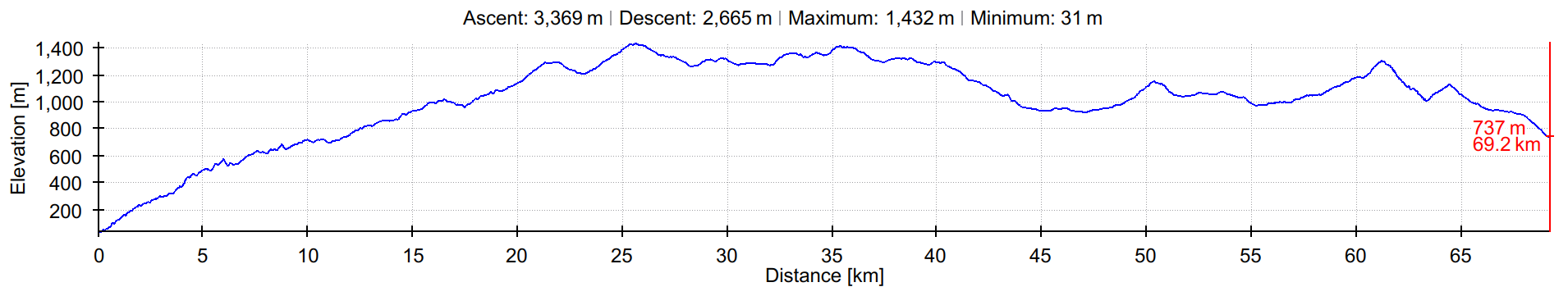
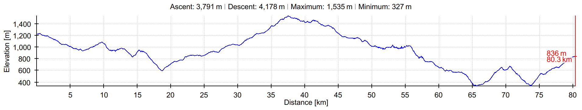
To make it through the city, we'll have a rolling start from a suitable start line location to the places where the tracks start: at the base of the climb up. Hot & dusty Dili is quickly left behind and below while we enjoy beautiful views of the city and the ocean. At about 500m altitude the routes join up until KM21 where Makaas will head south into the breezy Liquidoe highlands while Makaas rides west and around the beatiful Seloi Kraik lake.
Below are the provisional tracks. Note that there will be an extra 10K or so involved to get from the start line to the start of the tracks, and from the end of the tracks to the finish line.
| Makaas | Kapaas | |
|---|---|---|
| GPX track | Download | Download |
| KML track | Download | Download |
| Altitude profile | View | View |
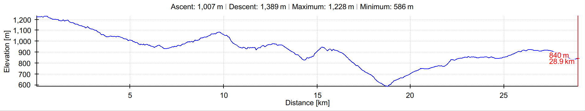
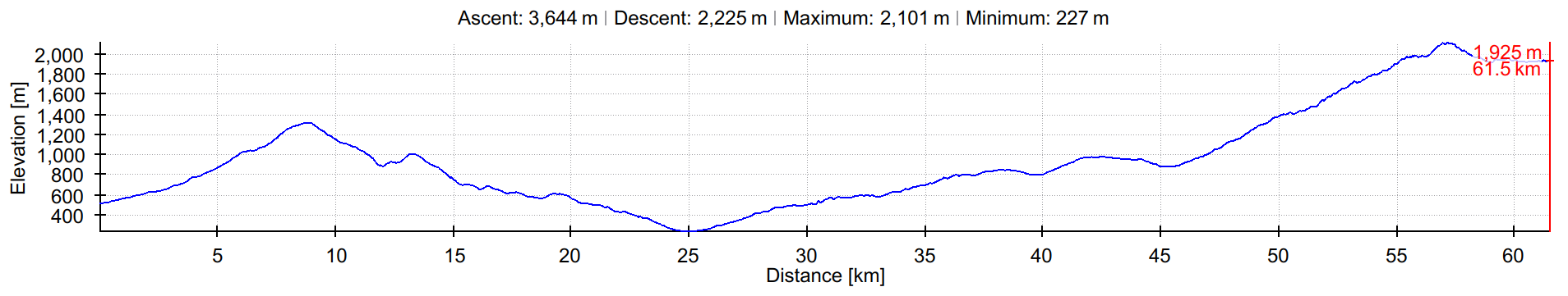
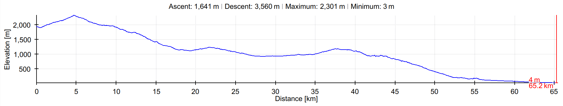
| Distance | 80 km | 65 km |
| Altitude gain (corrected) | ±2500 m | ±1500 m |
Stage 2: Monday June 24th: Gleno - Atsabe
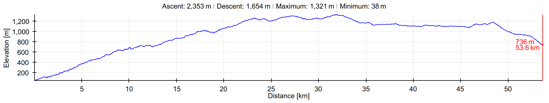
We're going to Atsabe, right next to the Mota Bandera falls which will suddenly reveal themselves to you coming down one of the last switchbacks of the day's ride. The last bridge to cross goes over a white water river with great pools to have a swim in after the finish! The Kapaas route features three major climbs: out of Gleno, then on to Letefoho ridge, then on to the last ridge after which you'll encounter the white water river coming from the Ramelau slopes. Among the many noteworthy things is a beatiful descent from Letefoho down on a winding tarmac road through stunning coffee bush landscape with expansive canopies of the "kafe inan" (coffee mother) trees, creating the right climate for the coffee bush below.
The Makaas route will take a left after the first climb, passing by a lake (we may see some pelicans) and then onwards and upwards on some pretty challenging trails, up the flanks of Mount Ramelau to about 2000m of altitude. There we'll scramble across a valley and commence the downhill, for which you quite likely will need both hands on the steering bar for most of the time.
| Makaas | Kapaas | |
|---|---|---|
| GPX track | Download | Download |
| KML track | Download | Download |
| Altitude profile | View | View |
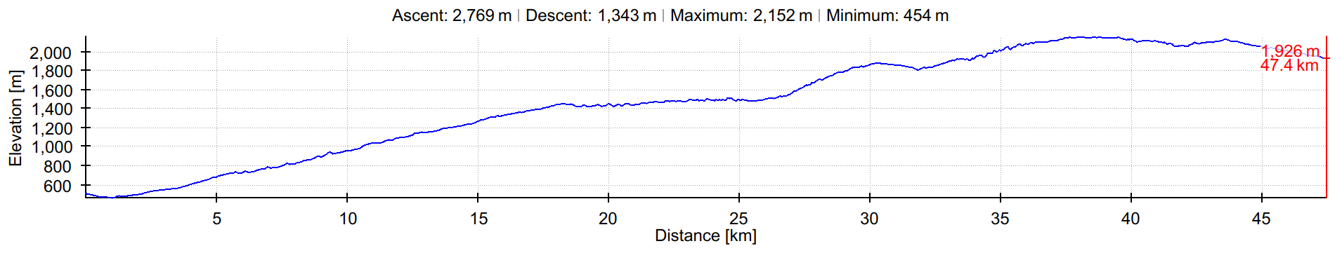
| Distance | 50 km | 50 km |
| Altitude gain (corrected) | ±2700m | ±1600 m |
Stage 3: Tuesday June 25th: Atsabe - Bobonaro
Not even 30K today for the Kapaas route — is this a picnic? Perhaps for some, but for many new to the sport, these Ks are not like the previous Ks. These are "special" Ks. No tarmac, only dirt, and the track is steep and stunning! As you're bombing down the trails, whistling, you'll ponder why the bicycle is not the transportation mode of choice in this country. You'll find the answer on the uphills.
The Makaas route today holds breathtaking vistas, on several occasions revealing the road ahead all the way on the other side of a valley — depending on your state of mind, these sights can be daunting or inspiring. There's a variety of landscapes waiting for you - there's high grazing lands, lush tropical forest, dry & dusty riverbed villages, and at the last river crossing you'll find yourself gazing up to the Ramelau mountain range from the best ramelaugazing angle in Timor. It's going to be a high-reward, high-effort day.
| Makaas | Kapaas | |
|---|---|---|
| GPX track | Download | Download |
| KML track | Download | Download |
| Altitude profile | View | View |
| Distance | 80 km | 30 km |
| Altitude gain (corrected) | ±3200m | ±1000 m |
Stage 4: Wednesday June 26th: Bobonaro - Same
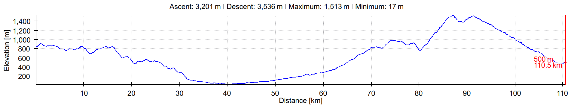
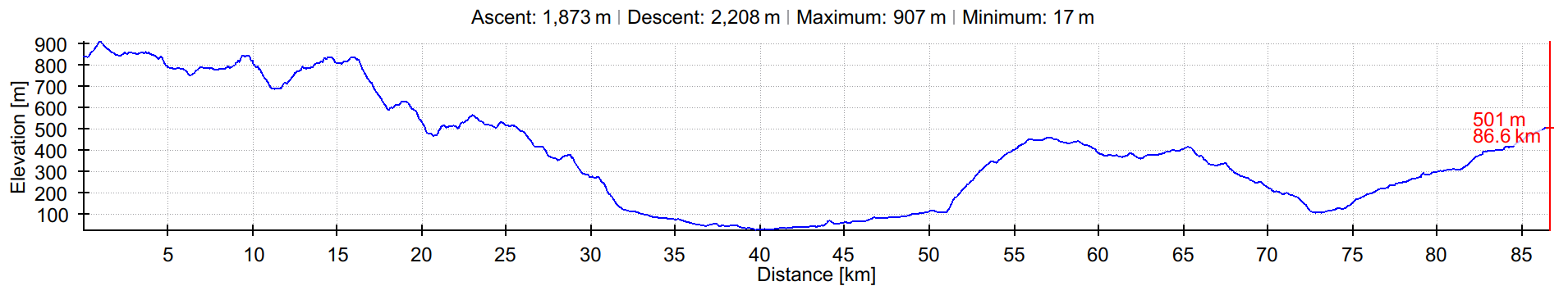
Wow, tough day for all! We'll start the day with a descent to the south coast, where we'll briefly be on the hot coast road. Apologies! It's the only way to get around the Ramelau massif without going back north. But it's only 15K! Soon we'll be climbing again. The Kapaas route will take a southern approach to Same. It's very scenic, but it's going to be hard to do this climb at the end of the day! Luckily the road is good, and yesterday was a picknick day so you're firing on all cilinders today!
At K50, the Makaas route bends north, forking off of the Kapaas route to casually loop around the massive Kablaki mountain. Not an easy thing to do at the end of the day! The reward is at 90K, 1500m, where tarmac starts and then it's a glorious 20K descent with smooth curves down a gorgeous gorge.
| Makaas | Kapaas | |
|---|---|---|
| GPX track | Download | Download |
| KML track | Download | Download |
| Altitude profile | View | View |
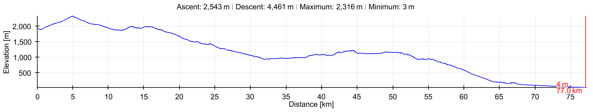
| Distance | 110 km | 85 km |
| Altitude gain (corrected) | ±3000m | ±1700 m |
Stage 5: Thursday June 27th: Same - Hatu-Builico
Target for the day: Hatu-Builico, the highest village in Timor! Hatu-Builico lies in a big bowl with mountains on all side, and Mt. Ramelau towering over it. Marvelous, but it does take a bit of climbin to get there, though.
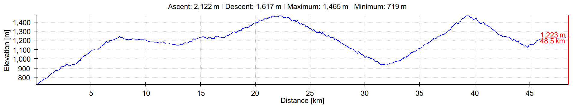
Kapaas riders will spend the morning chasing — and eventually overtaking — the rising 25 °C thermocline all the way up to the north-south watershed pass, at 1875m. It's ± 25K of sustained climbing up the gorge that the Makaas riders came down on the previous day — but it's good tarmac, not too steep, and there's shade and bananas to keep you going. At K33 we take a left for the cobbled mountain road to the village, where there's tea and hot showers.
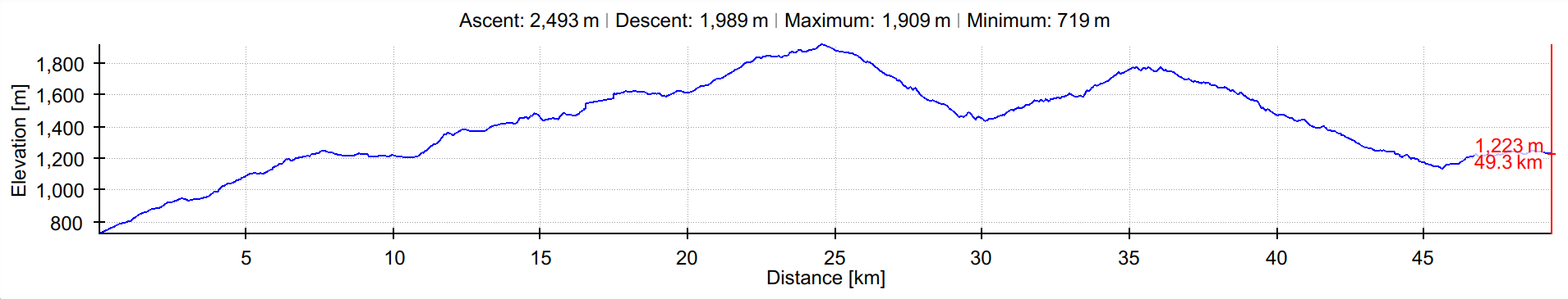
The Makaas route will start off with a steep climb straight up the south flank of Kablaki, rising from 500m to 1300m in the first 10K. Then at 11K, there's a bit of bushwhacking and hike-a-bike across a valley to make it to another ridge, from which a narrow trail leads down to a bridge at just 227m. From there the road is more road-like, but winding, up to Ainaro at K40, through which we passed yesterday. Given what's ahead it would not be a bad idea to ride into town for a solid lunch! We hop onto the main road and just before the point where yesterday you took a right to cross the gorge, we turn left where you'll be taking steep switchbacks up. And up. And up. The views will be amazing, you'll see the road you rode yesterday afternoon clinging to the Kablaki mountainside way over on the other side of this deep valley. Gradually it gets more alpine; at about 2000m we cross a ridge and the wide bowl that is the highland valley of Hato-Builico unfolds - and you can see the finish line from here!
| Makaas | Kapaas | |
|---|---|---|
| GPX track | Download | Download |
| KML track | Download | Download |
| Altitude profile | View | View |
| Distance | 60 km | 50 km |
| Altitude gain (corrected) | ±3300m | ±2200 m |
Stage 6: Friday June 28th: Hatu-Builico - Dili
We coast home, all the way from the highest crossroads in Timor to the coast — the finish line is at the beach! The day starts off in the chilly mountain morning with a good warm-up climb to get to the highest point of our route, 2300m. That's where the fork in the road is where the routes diverge. The Kapaas route will wind down a breathtaking road in a deep valley, crossing through various climate zones in just 10K - from mossy pines to flowering cactuses. Then, 20K of tarmac with two bits of climbing, to meet up with the Makaas route at the top of the ridge separating us from the coastal plains.
After the fork the Makaas route will descend for a while on the "wrong" side of the massif, getting very close to where they were in Stage 2. Then, things get more and more bucolic; roads turn into footpaths that we take to get to pop back over the ridge again to descend onto what is normally the end of a dead-end road — hence, special places. On the other side of the valley you'll see the winding road that the Kapaas route is taking down. After hitting tarmac it's a short descent until we turn off to start following a river through a landscape that is strangely familiar, across a hang bridge, and then grinding up on the desolate gravel road you went down on in Stage 1. Up to the beautiful Lagoa Seloi (lake), around it, and then… meet up with the Kapaas route.
The joint last bit is a grand fast 15K descent on a graded gravel/dirt road, to meet the Comoro river at about 20K from the finish. We ride the riverside all the way down to where it meets the sea. Popping out from under the bridge passage, the last 2K are perfect for pulling a sprint and beating a rival to the finish line, but watch out for that last sharp 300° turn to the right!
| Makaas | Kapaas | |
|---|---|---|
| GPX track | Download | Download |
| KML track | Download | Download |
| Altitude profile | View | View |
| Distance | 80 km | 65 km |
| Altitude gain (corrected) | ±2000m | ±1300 m |